Cycling through all six. Tap any point to stop.
Measured on six things
Step-by-step public transit guides to Europe's top spots.
Growth
35Very young product (0.5 years) with no visible reviews, GitHub activity, or community traction beyond the site's own claims of curated routes.
Screenshots
1 / 2
About this app
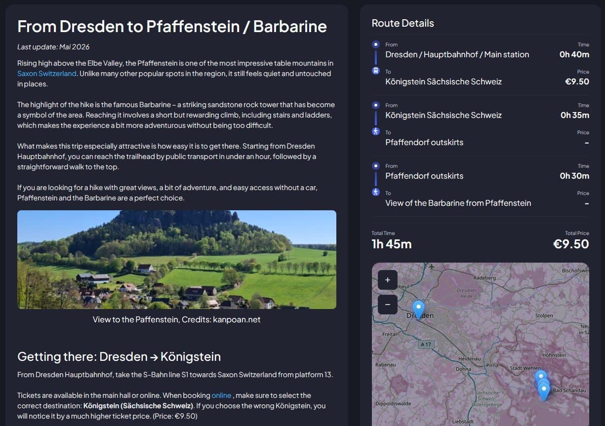
Kanpoan is a fantastic resource for anyone exploring Europe without a car. It offers detailed, step-by-step public transport routes to mountains, landmarks, and cities, with a focus on efficiency and stress-free travel. The site currently covers many popular routes, especially in and around Germany, like Dresden and Saxon Switzerland, but aims to expand across Europe. I love how it uses OpenStreetMap for mapping and Plausible for privacy-friendly analytics, and its community-driven route library is a goldmine for unique day trips. Whether you're planning a spontaneous getaway or a meticulously scheduled journey, Kanpoan simplifies the 'how to get there' part so you can focus on the experience.
Key features
- 1Step-by-step public transport routes with prices and practical tips based on real journeys
- 2Privacy-focused stack using OpenStreetMap and cookie-free Plausible analytics
- 3Community-curated popular routes focused on Germany and expanding across Europe
Target customer profile
Drawn from the product itself, not from a survey.
Demographic
Backpackers and budget travelers
Pain points
Difficulty navigating European public transport systems; high cost of car rentals
Primary needs
Reliable, low-cost transit options and clear itineraries
Demographic
Eco-conscious tourists
Pain points
Guilt over carbon footprint from driving or flying
Primary needs
Sustainable travel alternatives and green route suggestions
Demographic
Day-trippers from major cities
Pain points
Lack of time to research routes to nearby attractions
Primary needs
Quick, accurate connections from city centers to natural landmarks
Scout Review
Written by AI from measured evidence, scored out of 100.
Kanpoan carves a focused niche in car-free European travel planning with step-by-step public transport guides drawn from real journeys. Strengths lie in its privacy-conscious tech stack and straightforward route discovery, while weaknesses center on visual polish, missing accessibility details, and minimal market traction. It competes directly with broader tools like Rome2rio and Google Maps by emphasizing curated, local detail over global multi-modal coverage.
Measure by measure
Usability
62Straightforward free access to routes with clear CTA; login optional and privacy policy present, though onboarding depth is minimal for a new tool.
Design
58Average visual execution with cohesive dark theme and structured timelines, but hero form readability and truncated cards hurt polish.
Speed
68Strong desktop performance and solid mobile score; LCP at 4.7s keeps it responsive enough for route lookups without major lag reports.
Security
52HTTPS and several standard headers in place; missing HSTS, CSP, and DMARC plus zero published audits keep it at baseline for a small site.
Accessibility
68High automated score of 93 but missing image alt text; responsive design and readable contrast provide decent baseline support.
Growth
35Very young product (0.5 years) with no visible reviews, GitHub activity, or community traction beyond the site's own claims of curated routes.
Improvement areas
- Visual polish: add form labels, fix map contrast, and reduce text truncation on cards
- Accessibility: resolve missing alt attributes and consider broader WCAG documentation
- Growth: build external reviews, GitHub presence, and community engagement channels
Design & Usability
Kanpoan delivers a clean dark-themed interface focused on practical route timelines, though the hero planner suffers from missing labels and background clutter. Usability benefits from instant free access to community routes without mandatory signup, making it approachable for day-trippers. The about page reinforces real-world tested guides with prices and tips, while privacy emphasis via Plausible and OSM builds quick trust. Navigation is simple but the lack of deeper documentation or onboarding flows keeps it feeling early-stage rather than polished.
Speed & Security
Performance is respectable with Lighthouse scores of 83 mobile and 99 desktop, supported by fast TBT and zero CLS, though the 4.7s LCP suggests room for image optimization on maps. Security is functional with HTTPS, secure cookies, and several protective headers, yet the absence of HSTS, CSP, DMARC, and any third-party audits leaves it at a basic level suitable for a small indie project but not enterprise-grade. No breach history or complaints surfaced in research.
Accessibility & Growth
Accessibility scores well automatically at 93/100 despite one clear failing audit on alt text; the responsive layout and consistent typography support decent usability across devices. Growth remains limited by the product's youth (domain registered January 2026) and complete lack of external reviews, GitHub presence, or community signals, positioning it as an early-stage niche tool rather than an established player. Its privacy-first stance and OpenStreetMap integration offer a unique angle for eco-conscious travelers.
Conclusion
For budget backpackers and day-trippers targeting Germany and nearby regions, Kanpoan offers a promising specialized alternative worth watching as the route library grows.
Suggestions for improvement
- Add visible labels and improve contrast on the hero route planner form to boost immediate usability.
- Implement alt text for all images and publish a basic accessibility statement to strengthen compliance.
- Expand documentation with a help center or FAQ to reduce reliance on the privacy policy alone.
- Seed more routes and promote on Product Hunt or relevant travel forums to build visible traction.
Alternatives comparison
Named competitors, point by point. Nobody paid to appear here or to be left out.
 Kanpoan |  Rome2rio |  Google Maps | |
|---|---|---|---|
| Route detail level (step-by-step with prices/tips) | High - real-world tested guides with practical tips | Medium - multi-modal overview, less local detail | Medium - transit directions, limited curated tips |
| Privacy focus (analytics & data) | High - Plausible cookie-free, OSM mapping | Medium - standard privacy policy | Low - Google ecosystem tracking |
| Geographic coverage | Europe-focused, strong in Germany, expanding | Worldwide multi-modal | Global, strong public transit data |
Rome2rio
Offers multi-modal route planning worldwide, including flights, but can be less detailed for local transit.
Google Maps
Comprehensive public transit directions, but may lack curated guides for specific attractions.
Comparing options? See Kanpoan alternatives, scored side by side
Sources
What the review was written against. A verdict with no sources is an opinion.
More Travel & Exploration apps
View all Travel & Exploration
Peanut Tennis
89Find tennis courts & tournaments in Australia

Roami eSIM
88A global travel eSIM app offering instant activation, no ...

TheBean.ai
84Adaptive AI personal trainer that evolves with your progr...

EchoWi
83Track and optimize your brand's visibility in AI answers.

Stampsy App
83Find every country you've been to in your photos and collect a passport stamp for each one.

Bracket2026
82Interactive 48-team World Cup 2026 bracket predictor with...

Vote-n-Venture
79AI-powered group travel planning app that simplifies decision-making with collaborative voting and bookable itineraries.

SpeakSpots
78An AI-powered travel assistant that creates personalized itineraries via WhatsApp, perfect for quick and easy trip planning.
Remember
78An iOS app that enhances memory by capturing, tagging, and organizing items with smart contextual features.

Suitpax
78AI-powered CRM for corporate travel, streamlining workflows with AI assistants for itinerary planning and expense tracking.

Carpooly
76Carpooly is a smart carpooling platform that simplifies ride-sharing for schools, work commutes, and daily transportation needs.

LocoMap
76A user-friendly, privacy-focused platform for creating and sharing personalized maps with collaborative features.


A platform dedicated to providing unbiased reviews of newly launched applications, analyzing everything from their features to their full potential.
info@scoutforge.net© 2026 Scoutforge. All rights reserved.
